
Which State Has The Biggest Cartographic Ego?: Trends in US Streets named after US States
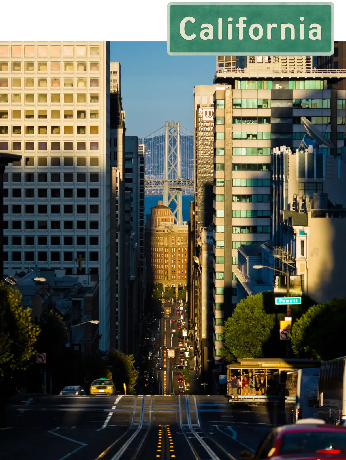
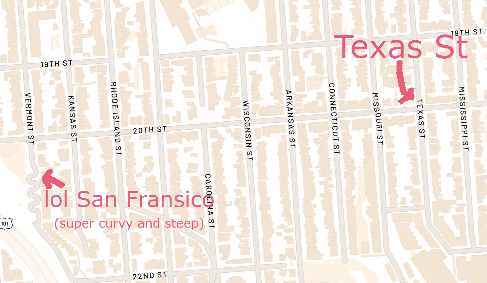
By David Gros. . Version 0.4.1 . Updated: Nov 12, 2025 Abstract: Street names can reveal what is important to a region. We explore patterns and visualizations of US street names. After looking at broad general trends in names (such as the most common street names), we narrow in on streets that include state names. We estimate there are 47,610 streets with a state name, with Washington in an understandable lead. There are ~94 streets with "North Dakota" in their name, but none of these streets are actually in North Dakota. Meanwhile, about 39% of the ~700 roads with "Wisconsin" in the name are in Wisconsin. There are several conflicting ways to compare usage of state names, making any exact ordering a toy exploration. We discuss these trends and how this analysis was done. Growing up in Texas, everyone knew Texas was the best state. We had Texas Hold’em, Texas Toast, Texas Longhorns, and more. But then fate took me west to California, a golden land which knows it is great, but perhaps shows less obvious signs of it. Sometimes though there are literal signs. Stretching across San Francisco there’s “California Street”, which can be stunningly beautiful, with rolling hills and the skyline framing the Bay Bridge. A view down California Street. Image credit KennyOMG on Wikipedia CC-BY-SA 4.0 But then head to the east part of the city, and, wait a second? Is that Texas St? And there's Vermont? And Mississippi? San Francisco's Potrero Hill Neighborhood. Map image via Mapbox. Apparently there are 30 streets named after states in San Francisco, California (28 unique states). Unfortunately 32 states didn't make the SF invite list. So California has a bunch of "State Sts" (which we will define as a roadway with a name that includes any state, such as "Nevada Lane", "Little Florida Avenue", or "Pennsylvania Run Road". Not to be confused with the actual 1,335 US Streets literally named "State Street"). Is this unusual? Which state has a Texas-sized ego, naming many streets after itself? And which is most humble, preferring instead to honor others? We download over 10GB of OpenStreetMap data, parsing through to explore this. We study the following research questions: There's a decent amount of nuance and complexity here. For example, what counts as a street (probably trails don't count, but do service roads)? What happens if a big park or neighborhood is built splitting streets into multiple unconnected parts? We try to make reasonable choices, and note our methodology in Section 4 as well as make our source code available. However, the analysis should be considered an estimate, not exact numbers. First, we gain an understanding of our streets data. After some processing, we have about 6 million streets. We start by looking at streets of any name (they don't have to be named for a state), before narrowing in on the counts of the "State Sts". Counting Every Street. In Figure 1 we plot the 10 most common street names. We find Main St is most common. Numbered streets make up 4 of the top 10. Nature-themed streets sprout up in four top spots. Church Street is the only place-themed street in the top ten. If you Google "what is the most common street name in the US?" you will get 2nd St in the summary result. It echoes a common explanation that Main St and 1st St compete with each other, so 2nd St wins out. This does not replicate in our data. The top source here seems to be from a 1993 census report. Chalabi (2014) reports investigating this and got in touch with the researcher who made the 1993 report, but the researcher couldn't remember their methodology. Our analysis has several advantages, being more recent as well as repeatable. Most Common Word. Next we split every name. The top values are shown in Figure 2. Interestingly "road" wins out over "street". "North" is the most common direction mentioned. Unusual Words Per State. Next we look at which words are unusual in the street names. We use an algorithm (tf-idf) that is used in search engines to find keywords. This algorithm identifies words that appear in streets of a given state, while also being unusual in other states. We plot these top two street keywords for every state in Figure 3. Additional methodology in Section 4.4. We can observe some patterns. For example, the use of Spanish words like "calle" and "de" appear in CA, AZ, and NM. "Lake" is a top choice of states like WI and MI, while New Hampshire only has "pond". Some keywords like "cemetery" in KY are a bit more mysterious. Next we look at streets where a state name occurs anywhere in the name. In total there are 47,610 roads with state names. Which States Are Most Common? In Figure 4 we plot the most and least common state names that appear in streets. We begin to see some complexity to this question. 9,535 roads have "Washington" in the name, dominating the count. However, it has an obvious confounder as it shares a name with George Washington. Somewhat interestingly, Washington's home state of Virginia comes in as the second most common state. While not a famous surname, it is a common given name. Virginia supposedly was originally named after Queen Elizabeth, the "Virgin Queen", and is more than twice as popular in street names than Georgia (named for King George II). For less clear reasons, Ohio comes in third (it was named for a Native American word for 'Great River'). We might speculate that it is partially because it is the shortest state name, making it an easy name to reuse, and it was a major hub during the 1800s westward expansion in the U.S. On the bottom end, the multiword states such as North and South Dakota appear less than 100 times. Notably though we require a full match of the entire state name. There are 1,451 streets that include "Dakota", no North/South mentioned. This nuance similarly applies for streets like York, Carolina, etc. Is this the right way to handle multiword states? 🤷♂️. It is a straightforward-to-define way. Next we explore how often states name streets after themselves. We investigate three ways of quantifying this "egotistical" vs "humble" factor. In-state vs out-of-state: In one perspective we could look at the fraction of the roads with a state's name that are in the state vs out of the state. So a state that frequently names roads after itself while no other state is doing so would rank highly here. This is shown in split bars of Figure 4, and is focused in as a percentage in Figure 5. Here we observe WI and TX on top. WI was a surprising state for the top spot. Fraction of all Streets: Another perspective is to look at all the streets in the entire state (of any name), and ask how many of them include the state name? This is shown in Figure 6. Here we observe Kansas on top. Roughly 1 in 220 streets in Kansas have the state in the name. In general, this metric biases against smaller population states (every state reasonably has a few key streets named after itself. Maybe one in each city. Having few overall streets makes this appear to be a high percentage). WI again appears in the top 7, but TX, with its many urban streets ranks 23 according to this metric (about 1 in 1000 Texas streets mention "Texas"). Self-naming vs other-naming: Finally we examine naming roads with one's self vs naming with other states. Perhaps some of the states with a lot of in-state references in Figure 4 just generally really likes roads with state names? To issolate this Figure 7 shows how often the state does itself vs chooses other states. Here we see Hawaii leads with over 40% of its state-named streets being self-named, followed by Virginia and Alaska. ND and DC have about 100 streets with state names despite not having a street single any with their own name. Aggregate Ranking: So where does that leave us? Our different ranking measures are not exactly consistent. To reconcile this we take an average ranking across all three of these to get an overall toy "ego/humble" ranking. By this measure we observe WI, KS, and IA most using their state name, and ND, SC, and NH at the bottom. The full combined ranking is shown in Table 1. New York, interestingly, is the 5th-most "street name humble". This is likely for the better, as potentially having your street address be "123 New York Street, New York City, New York" sounds awful. Additionally, a map of all 47,610 identified "State Sts" can be found here. We analyze data from OpenStreetMap (OSM), which is like Wikipedia but for maps. OSM is a core part of powering digital maps, and is supported by over 100,000 individual contributors and is sponsored by major companies such as Microsoft, Meta, and TomTom. The OSM data comes in a protobuf format containing nodes (points), ways (connected sequences of nodes), and their associated metadata tags. We identify all nodes that are part of named highways (all kinds of roads are "highways" in OSM). The extract the coordinates for these nodes and build street segments from ways. One challenge is that a single logical street (like "Main Street") can consist of many disconnected segments. This can be for somewhat simple reasons, such as a intersection, or when the speed of the road changes. It can also be in weird reasons like when you had one street but then a park or railroad or a neighborhood was built, splitting the street up multiple times. To identify unique streets, we group segments with the same name that share nodes, and then further merge nearby disconnected components if the either node is within 1 mile of each other. It is unclear if this the right threshold. There is a compromise on not overcounting vs not undercounting roadways which are truely distinct. We filter to only the top 7 main roadway types, which covers about 90% of the named roads. Things like pedestrian walkways, service roads, as weird labels like the 2443 named bridleways for horses or 1285 raceways get excluded. When we first ran the state-name analysis, we noticed a few states (particularly NV, VT, NM) had a large number (>20%) of their state streets with numbers in them. For example, "Vermont Route 78" whereas most states did not include the state name in these kinds of highways. We make the debatable choice of filtering these out to focus on unique non-numbered streets. To identify distinctive words for each state (Figure 3), we adapt the TF–IDF method (Spärck Jones, 1972). Each street name is treated as a document, and we use binary TF (0 or 1), so TF–IDF simplifies to just the IDF score. For each word, IDF = ln(total streets / number of streets containing the word). We sum these scores for all streets in each state and use them to rank words. To avoid common terms, we drop the 25 most frequent "stop words" (like road, street, avenue) and require at least 10 occurrences of a word in a state to include it. Analysis at the State Level. This can result in some streets being double-counted if they cross state boundaries. Merging Process Is Noisy. We merge streets with the same name within 1 mile of each other. Additional streets like "East Ohio St" and "West Ohio St" are treated separately. Making different decisions can shift counts. OpenStreetMap Completeness. While OSM is likely fairly comprehensive in the US, it is not perfect. This can create gaps. Additionally, certain areas might be systematically mislabeled. Street names are fascinating to play around with, and offer a glimpse into a geographic diversity. I found it interesting that the "2nd Street Is Most Common" adage from prior work didn't replicate. By the toy definitions several states like WI, KS, and IA name streets after themselves comparatively more ("cartographically egotistical"), but obviously this is just a toy exploration with many factors here. Some state pride and naming is admirable. Given how common state names are, it is surprising North Dakota doesn't have a single street named after itself, but 31 other states still appreciate it. There topn of cool things things to explore with this data. During parsing I estimated the length of streets, but haven't done anything with it yet. There are many other categories to explore. Let me know if you have any feedback or thoughts here! Others have a much better street-level view to the quirks of their local state's naming, and it would be interesting to hear perspectives. Also, it would be fun to get gather some actual pictures of the street signs with a distinctly not-that-state background. Let me know if you get any neat ones.
Introduction
Most Popular State Names
Overall Street Names


Streets with State Names

Which States are "Egotistical" or "Humble"?


State In-State % State Fraction % Self-Named Fraction Avg Rank Wisconsin 1 (39.1%) 6 (0.206%) 5 (23.6%) 4.0 Kansas 4 (30.7%) 1 (0.448%) 13 (17.9%) 6.0 Iowa 12 (20.6%) 2 (0.287%) 14 (17.7%) 9.3 Oklahoma 3 (34.3%) 5 (0.207%) 21 (15.5%) 9.7 Michigan 13 (20.3%) 10 (0.167%) 9 (19.9%) 10.7 Minnesota 5 (28.5%) 17 (0.141%) 16 (16.9%) 12.7 Nebraska 17 (16.0%) 7 (0.193%) 15 (17.5%) 13.0 Texas 2 (38.5%) 23 (0.108%) 18 (16.2%) 14.3 Idaho 25 (13.2%) 9 (0.179%) 10 (19.5%) 14.7 Montana 33 (10.1%) 4 (0.261%) 12 (18.7%) 16.3 Virginia 37 (8.4%) 12 (0.158%) 2 (27.9%) 17.0 Illinois 6 (26.9%) 15 (0.147%) 31 (11.3%) 17.3 Delaware 45 (3.7%) 3 (0.285%) 6 (23.3%) 18.0 Kentucky 26 (12.4%) 21 (0.115%) 8 (20.6%) 18.3 Missouri 11 (23.3%) 19 (0.120%) 26 (12.8%) 18.7 Alaska 36 (8.7%) 20 (0.118%) 3 (26.6%) 19.7 Oregon 32 (10.5%) 16 (0.146%) 11 (19.2%) 19.7 Indiana 16 (19.4%) 11 (0.159%) 32 (11.0%) 19.7 Washington 48 (2.5%) 8 (0.191%) 4 (26.0%) 20.0 Ohio 20 (15.1%) 18 (0.133%) 23 (14.9%) 20.3 Alabama 21 (14.9%) 26 (0.091%) 17 (16.2%) 21.3 Colorado 28 (11.8%) 14 (0.151%) 24 (13.8%) 22.0 Hawaii 41 (6.0%) 25 (0.095%) 1 (42.3%) 22.3 Louisiana 14 (19.6%) 24 (0.104%) 30 (11.3%) 22.7 Maryland 30 (11.2%) 22 (0.115%) 19 (16.2%) 23.7 Florida 7 (26.7%) 27 (0.089%) 37 (10.7%) 23.7 California 8 (25.9%) 34 (0.070%) 33 (10.9%) 25.0 Arkansas 15 (19.6%) 30 (0.083%) 35 (10.8%) 26.7 Georgia 27 (12.0%) 32 (0.074%) 22 (15.5%) 27.0 Arizona 24 (13.3%) 29 (0.084%) 28 (12.0%) 27.0 Pennsylvania 19 (15.4%) 28 (0.088%) 36 (10.7%) 27.7 South Dakota 10 (25.3%) 31 (0.075%) 42 (5.7%) 27.7 Tennessee 22 (13.9%) 36 (0.063%) 27 (12.2%) 28.3 Maine 31 (10.6%) 38 (0.061%) 20 (15.5%) 29.7 Wyoming 44 (4.9%) 13 (0.157%) 34 (10.9%) 30.3 New Jersey 9 (25.5%) 39 (0.053%) 43 (4.5%) 30.3 Vermont 49 (1.9%) 37 (0.061%) 7 (21.4%) 31.0 Nevada 43 (5.2%) 33 (0.074%) 25 (13.3%) 33.7 Massachusetts 23 (13.8%) 43 (0.036%) 41 (6.3%) 35.7 North Carolina 18 (15.6%) 48 (0.007%) 47 (1.9%) 37.7 Mississippi 34 (9.8%) 40 (0.052%) 40 (9.2%) 38.0 Rhode Island 42 (5.5%) 35 (0.068%) 38 (9.3%) 38.3 West Virginia 29 (11.8%) 42 (0.040%) 46 (3.7%) 39.0 Utah 46 (3.1%) 44 (0.030%) 29 (11.8%) 39.7 Connecticut 39 (6.9%) 41 (0.044%) 39 (9.3%) 39.7 New York 35 (8.7%) 45 (0.028%) 45 (3.9%) 41.7 New Mexico 38 (7.8%) 47 (0.012%) 48 (1.4%) 44.3 New Hampshire 47 (2.8%) 46 (0.015%) 44 (4.2%) 45.7 South Carolina 40 (6.9%) 49 (0.005%) 49 (1.3%) 46.0 North Dakota 50 (0.0%) 50 (0.000%) 50 (0.0%) 50.0 Methodology
Processing Data
Filtering
Keyword Analysis
Limitations
Conclusions
#/media/File:Califstreet_2a.jpg)